YIPPR.ES ≡ Torani Europe Maps Grassland Machinery Rochester Midland
  • Vintage Maps

  • Thomas Scott Van Diemen’s Land 1824

Thomas Scott Van Diemen’s Land 1824

$36 $45.72
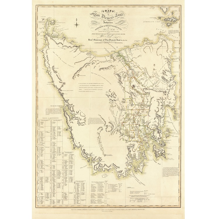
Description Thomas Scott Van Diemen’s Land 1824 Thomas Scott (1800-1855) emigrated to Hobart Town in 1820 and became Assistant Surveyor General under George Evans in 1821. From 1822 to 1824 he explored and mapped parts of Tasmania’s east coast, laid out the town of Bothwell, and published this map of Van Diemen’s Land. He became Surveyor General of Van Diemen’s Land in 1825. This Van Diemen’s Land Map features land grant information, distances from Hobart, and includes comment on topography and settlement.
Vintage Maps

Vintage Maps

  • Antarctica 1939 Wall Map
    $23.91 $44.47
  • Typus Orbis Terrarum Map Print
    $26.92 $51.69
  • Tasmania 1859 – James Sprent
    $18 $25.38
  • Freycinet Chart 1802
    $36 $46.08
  • Aboriginal Tribes of Australia Map 1940
    $24.12 $46.31
  • Tasmanian Shipwrecks Map
    $11.96 $14.83
  • Van Diemen’s Island Tasmania 1851 Print
    $36 $53.64
  • Nova Totius Terrarum Orbis Geographica
    $30.8 $54.82
  • Port of Hobart – Deep Water Port Australasia Print
    $16.74 $31.81
  • Jarman’s Map of Hobart Town 1858
    $12.54 $15.3
  • Robinson’s Aeroplane Map of Sydney
    $21.07 $40.24
  • Australia Tallis Map Print
    $36 $64.44
  • Thomas Scott Van Diemen’s Land 1824
    $36 $45.72
  • Hobart Town ‘Balloon’s Eye’ Sketch Print
    $21.86 $29.29
  • Melbourne Bird’s-Eye View Print 1871
    $54 $95.58
  • Map of the City of Hobart 1927
    $21.78 $26.57

© 2026 - YIPPR.ES